Route 66 Thru Arizona
Route 66 slices horizontally through the State of Arizona exposing some of the best historic artifacts and Americana in the USA. This article explains what you’ll find along the original alignment of Route 66 through Arizona. The accompanying two videos will visually show you what you’ll find along this 385 mile-long stretch of the Mother Road in Arizona. Scroll down this article and you’ll also see several renderings of historic scenes by prolific Route 66 artist, Bob Waldmire.

Learn more about authors Cliff & Ilene Bandringa
This article and the two videos below are designed for anyone planning on exploring the historic attractions along Route 66 through Arizona. Watch the videos to see what we saw and/or continue reading below to learn more about these places and our suggested touring route. Be sure to explore the hyperlinks scattered throughout this article that link to other websites and articles that further explain specific places or terms.
Part 1: Lupton (New Mexico Border) to Flagstaff

Part 2: Williams to Topock (California Border)

About Route 66
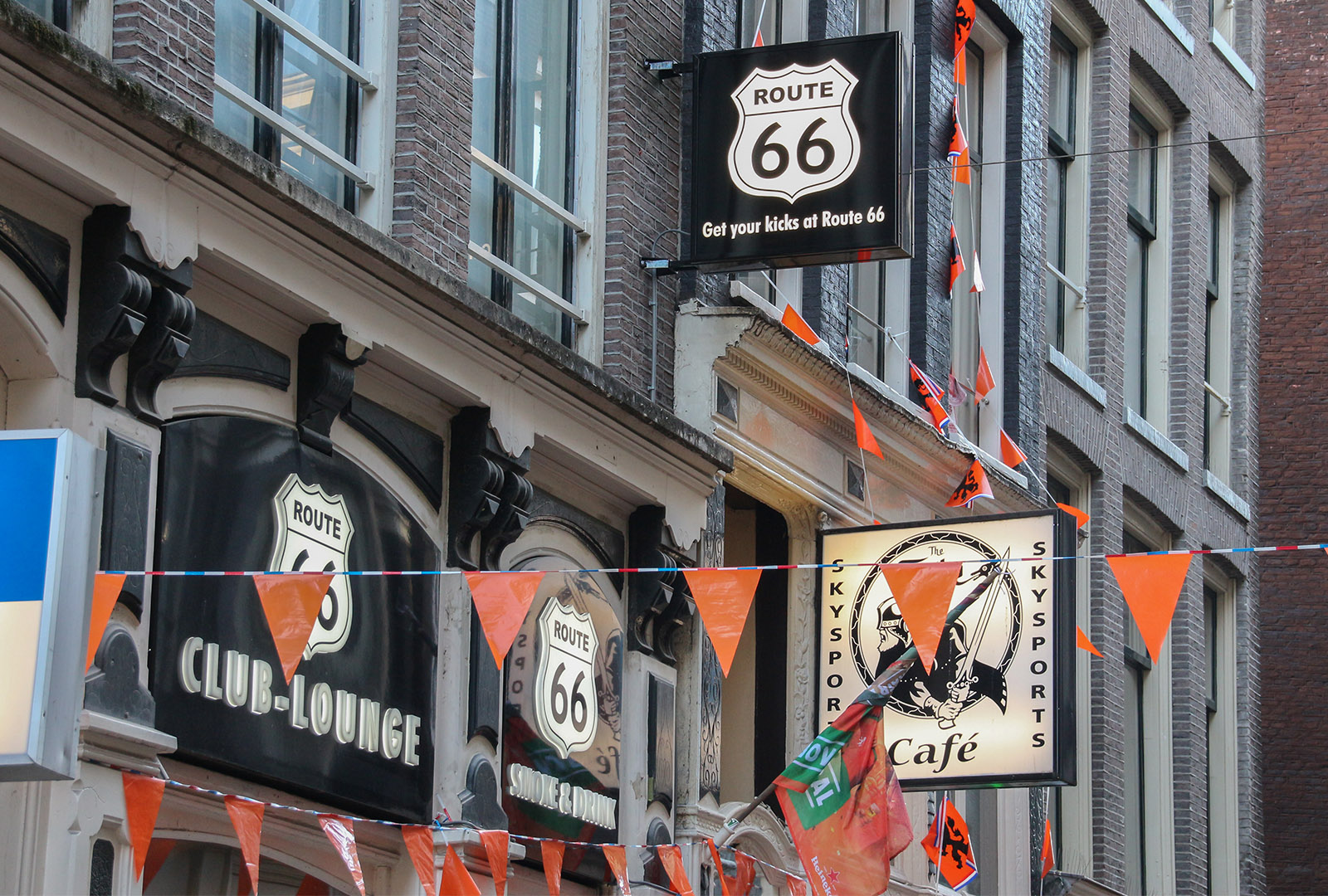
Route 66 is probably the most well-known and popular road trip destination in the United States, if not the World. When we travel around Europe, the Route 66 highway shield appears in just about every city we’ve visited. Numerous travel companies offer sight-seeing tours of the old road in different states. Across the USA, signs mention Route 66, and people wear Route 66 shirts and hats. Without a doubt, Route 66 is well known throughout the World.
As mentioned, Route 66 is loaded with pure Americana. Thanks to the many preservationists and historical associations that wish to preserve America’s history, there’s a lot of neat things for all of us to go out and see. Many of the things seen in our videos are explained more in this article.
Its Beginnings
Keep in mind that Route 66 was established in 1926, but it utilized many existing roads that were established in the late 1800s and early 1900s. Originally, there were numerous pioneer trails and later the Santa Fe Railroad (initially the Atlantic and Pacific) established a fixed route through Arizona in the 1880s. Later, in 1912, when automobiles appeared on the scene, the National Old Trails Road was established and linked the East Coast to the West Coast. When Route 66 was commissioned in 1926, it used the same alignment through Arizona. East of Arizona, National Old Trails Road took a very different route (not the same alignment that Route 66 follows).
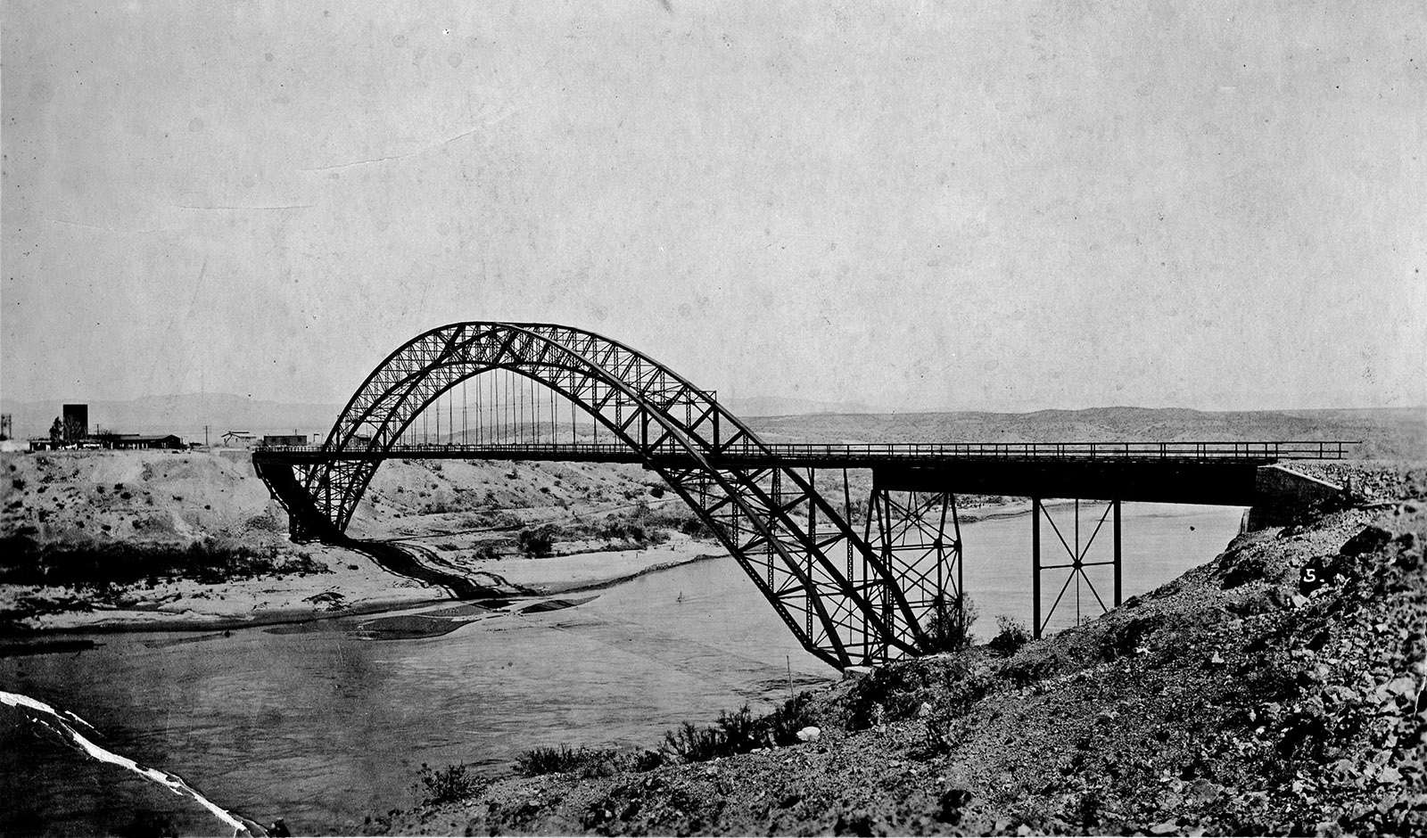
Old Trails Bridge over Colorado River circa 1920 – click to enlarge
Much of what you’ll see along Route 66 today are the remains from the early 1900s through the 1970s, plus newer “artifacts” that preservationists added later. Starting in the mid 1960s, the replacement to Route 66 was being built, Interstate 40. Unlike Route 66, which stretched from Chicago to Los Angeles, I-40 crosses the USA from Wilmington, North Carolina, to Barstow, California. As I-40 was built across the eastern half of Arizona, it was mostly built on top of the old alignment of Route 66, literally erasing it many places. On the western half however, I-40 took a shorter path, leaving much of the old Route 66 alignment intact.
Since part 1 of the video tour covers the eastern half of the state, it covers Route 66 where it mainly serves as a main street through a town, such as Winslow. Part 2 of the video covers much of the original “drivable” road as I-40 passes mainly to the south of Route 66’s alignment.
Bob Waldmire
During the videos, you’ll hear about the prolific artist, Bob Waldmire. Before he left us in 2009, he created numerous informative drawings and paintings of places along Route 66, especially in Arizona.
Where available, the video compares what Bob painted (most of his paintings are from 1990 until 2008) to similar scenes we found around 2020-2024. In the article below, you’ll find several of Bob’s paintings, along with his explanations about a given place, that he wrote out in his meticulous writing font.
Below is an example of one of his paintings of Route 66 in general:
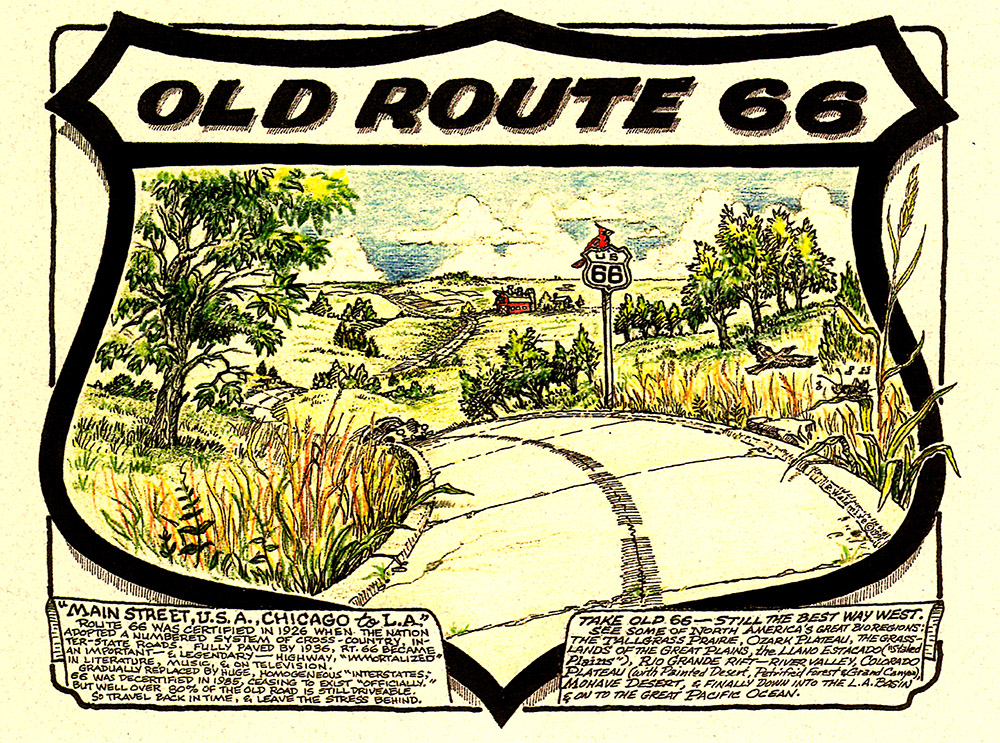
Click to enlarge – click off image to close
Bob Waldmire Picture Gallery
Images are in order of traveling from east to west (in the direction of the tour).
-

- La Posada Harvey House

-

- Downtown Winslow

-

- Museum Club, Flagstaff

-

- Flagstaff train station

-

- San Francisco Peaks

-

- Ash Fork street scene

-

- Angel's Barber Shop, Seligman

-

- Frontier Motel, Truxton

-

- Santa Fe train in Truxton Canyon

-

- Hackberry Route 66

-

- Hackberry General Store

-

- Cool Springs along Oatman Hwy

-

- Oatman Main Street

-

- The Needles & Topock

The Tour
Unlike our other Route 66 tours covered in our blog, this article covers the old road through the entire state. As seen in our virtual video tours above, this article and videos also serve as a photo essay of the historic places and Americana found on Arizona’s segment of Route 66.
Our tour runs across Arizona from east to west. We chose this direction because it’s the same route that countless travelers would have taken during the highway’s heyday. Just like in the classic movie, the Grapes of Wrath, they traveled from the dust bowl of Oklahoma in the east, to the hopeful land of prosperity in the west.
From east to west the places we’ll visit include:
- Lupton
- Petrified Forest National Park
- Holbrook
- Joseph City & Jackrabbit
- Winslow
- Two Guns
- Twin Arrows
- Walnut Canyon National Monument
- Winona
- Flagstaff
- Williams
- Ash Fork
- Seligman
- Grand Canyon Caverns
- Peach Springs
- Truxton
- Valentine
- Hackberry
- Antares
- Kingman
- Oatman
- Topock
Lupton
As mentioned, our journey begins on the New Mexico, Arizona state line, in the town of Lupton. Just inside the Arizona border, you’ll find a number of classic Native American trading posts that existed before the 1940s. Lupton actually started life as a stagecoach stop before mechanized travel. Later, when Route 66 began attracting travelers, the local area Native Americans built their trading posts along the road to sell their unique crafts, such as rugs, pottery and jewelry.
The most prominent trading post here is the Yellowhorse trading post. It’s been family owned and operated for most of its existence. David Yellowhorse installed the animals you see on the ridge above the buildings. Later, along our tour west on Route 66, you’ll see that models of animals and various creatures, was a common theme during the old road’s heyday. The neighboring trading posts are also worthy of perusing.
A short segment of Route 66 still exists on the east side of I-40. You’ll need to get onto I-40 at the next intersection to the west.
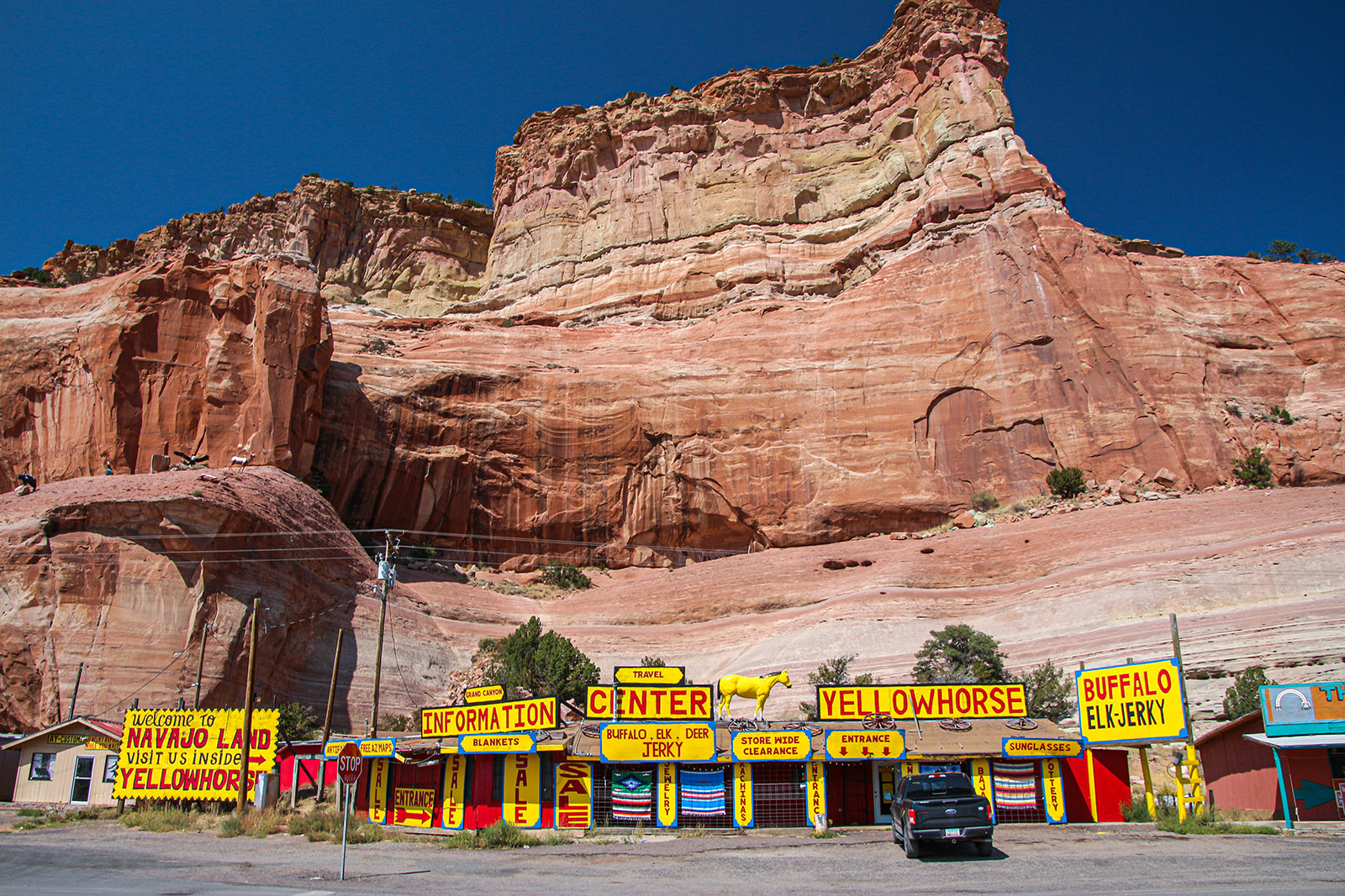
Yellowhorse Trading Post – animal models halfway up ridge on the left
Fort Courage
On I-40, take exit 348 to visit the remains of a Route 66 attraction. Fort Courage was primarily a child’s attraction along Route 66. It was a mockup of the fort used in the popular TV show, F Troop, that aired from 1965 until 1967. When we visited, all that remained were the ruins seen in the video and there were no signs of any business here being open.

Petrified Forest National Park
The next point of interest along our tour is Petrified Forest National Park, which is accessed from exit 311 from I-40. One can easily spend a day or more here looking at all the unique scenery preserved by this park.
Although exit 311 will take you to the park’s visitor center and one of its grand viewpoints, providing you have enough time, we recommend traveling through the park from south to north. The reason for this direction is for the lighting. This way, the sun will be behind you the whole way and will not hinder your vision. If you’re coming from the west, exit at Holbrook and then head to the south entrance to the park, which is called Rainbow Forest. If you’re traveling the direction of our tour (coming from the east), take exit 311 but drive non-stop to Rainbow Forest, then turn around to go north.
Most of the park and its famed petrified wood is on the south side of I-40. However, the visitor center, gift store, several viewpoints of the Painted Desert, and the historic Painted Desert Inn is located on the north side. There’s also a visitor center on the south side at Rainbow Forest. That way, you can get information no matter which direction you’ll be driving.
If you visit all the sites in the park, mainly on the one road that goes north-south, it can take all day. But if you spend just brief periods of time, it can be done in half a day or less. There’s lot of interesting and color sights to see here, so you don’t want to miss out. If you’re planning to stay a day or more, we recommend either getting a hotel room in nearby Holbrook or Winslow. There are no campgrounds in the park, but Homolovi Ruins State Park or Clear Creek Lake near Winslow have campgrounds.
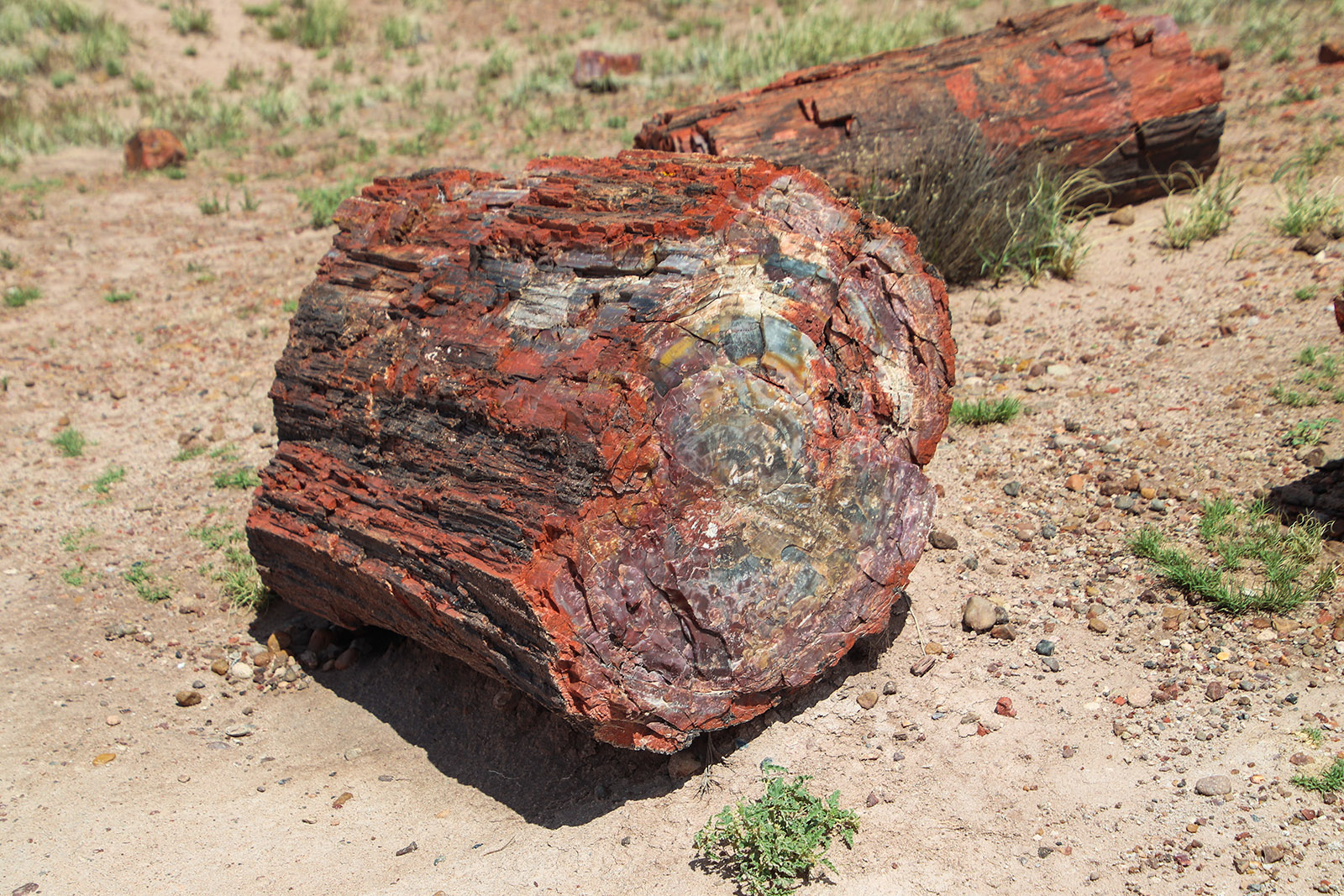
Petrified Wood
Petrified Wood Shops
On I-40 heading west from exit 311, a stop at exit 303 or Adamana Road will lead you to two interesting petrified wood shops. One shop is called Stewart’s. The property butts up against the national park boundary where there is a significant amount of petrified wood. The specimens that the owner sells is simply dug up with a backhoe.
You’ll see that Stewart’s also displays a lot of interesting, almost corny or campy, decorations. The owner placed these items here during Route 66’s heyday. Back then, travelers from the east would have never seen anything like this before, making this place real special to them. Today, most people will laugh at these old artifacts, but in the 1950s they were cherished.
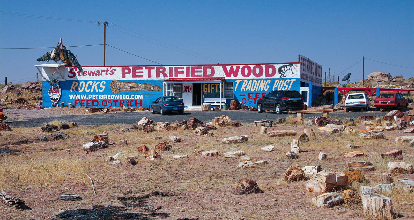
Steward’s Petrified Shop
On the south side of I-40 is the Painted Desert Indian Center. It too offers petrified wood as well as other Native American goods. Keeping with the petrified wood Triassic theme, you’ll see more models of what animals may have looked like from that prehistoric era, standing around. There’s also plenty of models of Native American features to be seen here. Although we are near the Navajo Nation, the models you’ll see depicted here is mainly from the Hopi culture. The Hopi and Navajo are two very different Native American cultures. The Hopi Reservation is roughly 30-50 miles northwest of here.
Next to the Indian Center, you’ll see a deteriorating bridge that once carried an immeasurable amount of Route 66 travelers before I-40 was built. Between Lupton and Flagstaff there are many abandoned and deteriorating bridges that was once used by both Route 66 and National Old Trails Road. Between Flagstaff and Topock, many of the old bridges are in use and being maintained.
Holbrook
The next stop on our tour is Holbrook. We’ll take exit 286 and drive Hwy 77 southbound, which is the old 66 alignment. Although I-40 services Holbrook with three exits, not many people have a reason to visit this historic town anymore. Sadly, since I-40 was built, the town has been slipping slowly into decay – a common theme all along historic Route 66.
Holbrook was founded in 1882 by the Atlantic and Pacific Railroad. The city was named after Henry Randolph Holbrook, chief engineer of the Atlantic and Pacific.
What Holbrook does offer are numerous old buildings sporting wonderful paintings. It’s worthwhile either driving around the streets or getting out to walk around to admire the paintings. After the alignment of Route 66 makes a 90 degree right turn to the west, there is more classic Americana to enjoy, such as the famous Wigwam Motel, several old restaurants sporting neon signs, and assorted motels.
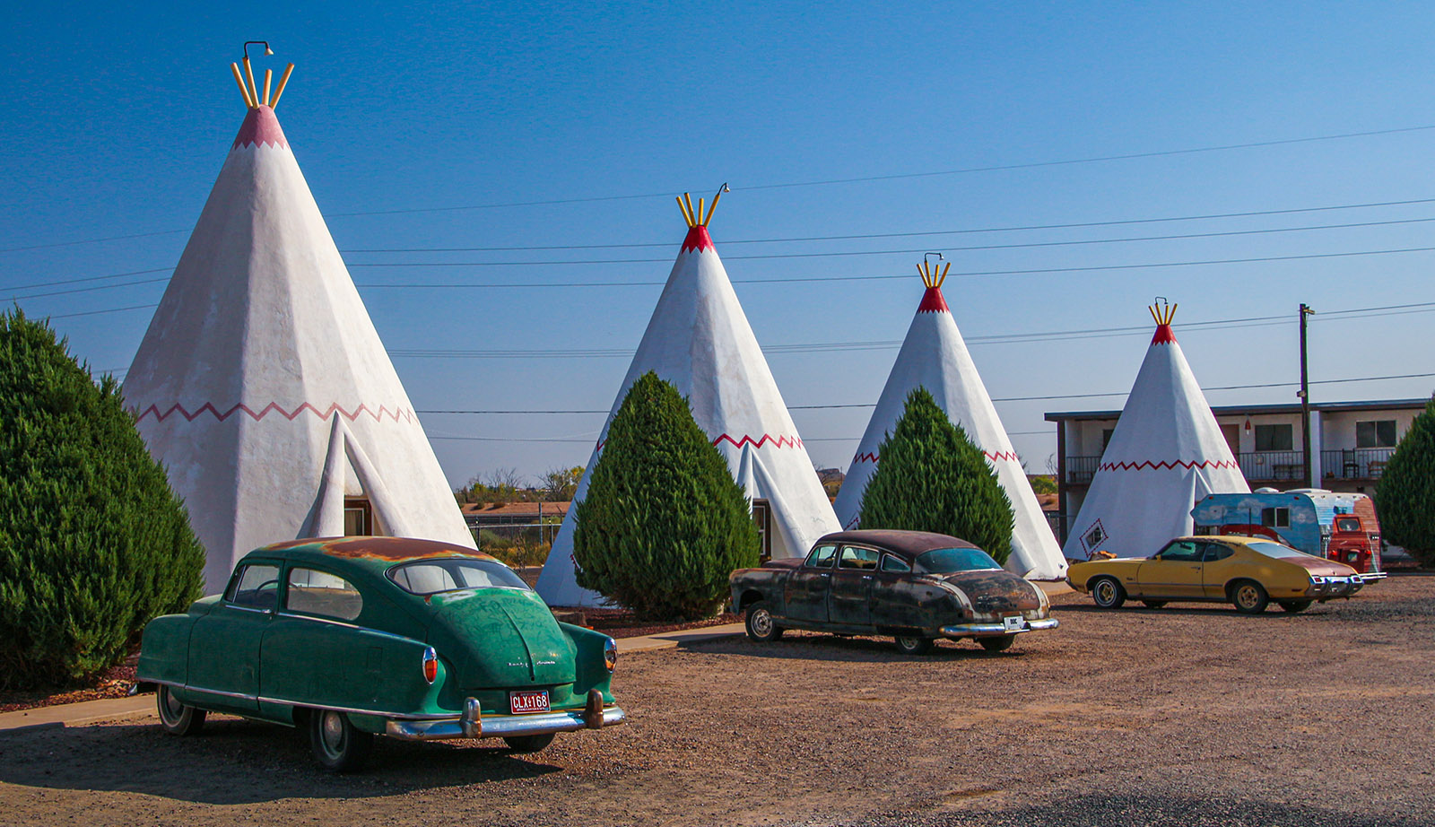
Wigwam Hotel in downtown Holbrook
Since Holbrook is the county seat here, there is a classic old courthouse situated just off Hwy 77 and Route 66, that now serves as the Navajo County Historical Society museum. According to their website, they are open seven days a week.
Just south of the intersection where Route 66 turns west and Hwy 77 continues south, you’ll see Holbrook’s historic railroad depot. The depot has been nicely restored. Its historical significance comes from when Geronimo, the famed Apache military leader, surrendered in 1886 and was taken to this depot to be sent to a prisoner of war camp in Florida.
Further south, past the depot, is a very large petrified wood shop. Unlike the other shops along I-40, this one specializes in gem-quality specimens, as well as very large pieces of petrified wood. Walking around this store is almost like walking around a museum. In our opinion, this is a worthwhile stop. Incidentally, the road this shop is on leads to the southern end of Petrified Forest N.P. discussed earlier.
Support Us
Help us fill up our tank with gas for our next trip by donating $5 and we’ll bring you back more quality virtual tours of our trips!
Your credit card payment is safe and easy using PayPal. Click the [Donate] button to get started:

Joseph City
Not far west of Holbrook is Joseph City. Take exit 277 from I-40 to see this small town and it’s unique attractions.
Joseph City, originally named Allen’s Camp, then St. Joseph, was founded in 1876 by pioneers from the Church of Jesus Christ of Ladder-Day Saints, also known as Mormons. Joseph City was named after the church’s founder, Joseph Smith.
Less than a mile from exit 277, on the right, you’ll see a display of historical pioneer artifacts. Not an official museum, this private collection of antiques and artifacts is sometimes open to visitors. As you walk around looking at all the artifacts, you’ll appreciate the hardships these pioneers went through to settle the west during the late half of the 1870s. Living here was tough enough, but the story of the pioneers originally getting here was even more rough, which consisted of crossing long expanses of Utah desert and over the canyonlands of what is now Lake Powell.
Driving a little further west will bring you to downtown Joseph City. Here you’ll find a smattering of old businesses and houses following the typical Mormon architectural style found throughout Utah.
Jackrabbit
After exiting Joseph City to the west, don’t jump back on I-40. Instead, cross over the freeway to the south side, then turn west onto an old segment of Route 66. In five miles, you’ll encounter one of the more famous tourist attractions along the old road, Jackrabbit.
During Route 66’s heyday, Jackrabbit Trading Post was well known for its signs located along the road from Missouri to Arizona, indicating how far it was to Jackrabbit. When you arrived, the final Jackrabbit sign indicated, Here It Is. Incidentally, this sign was depicted in the 2006 movie, Cars, mentioned earlier.
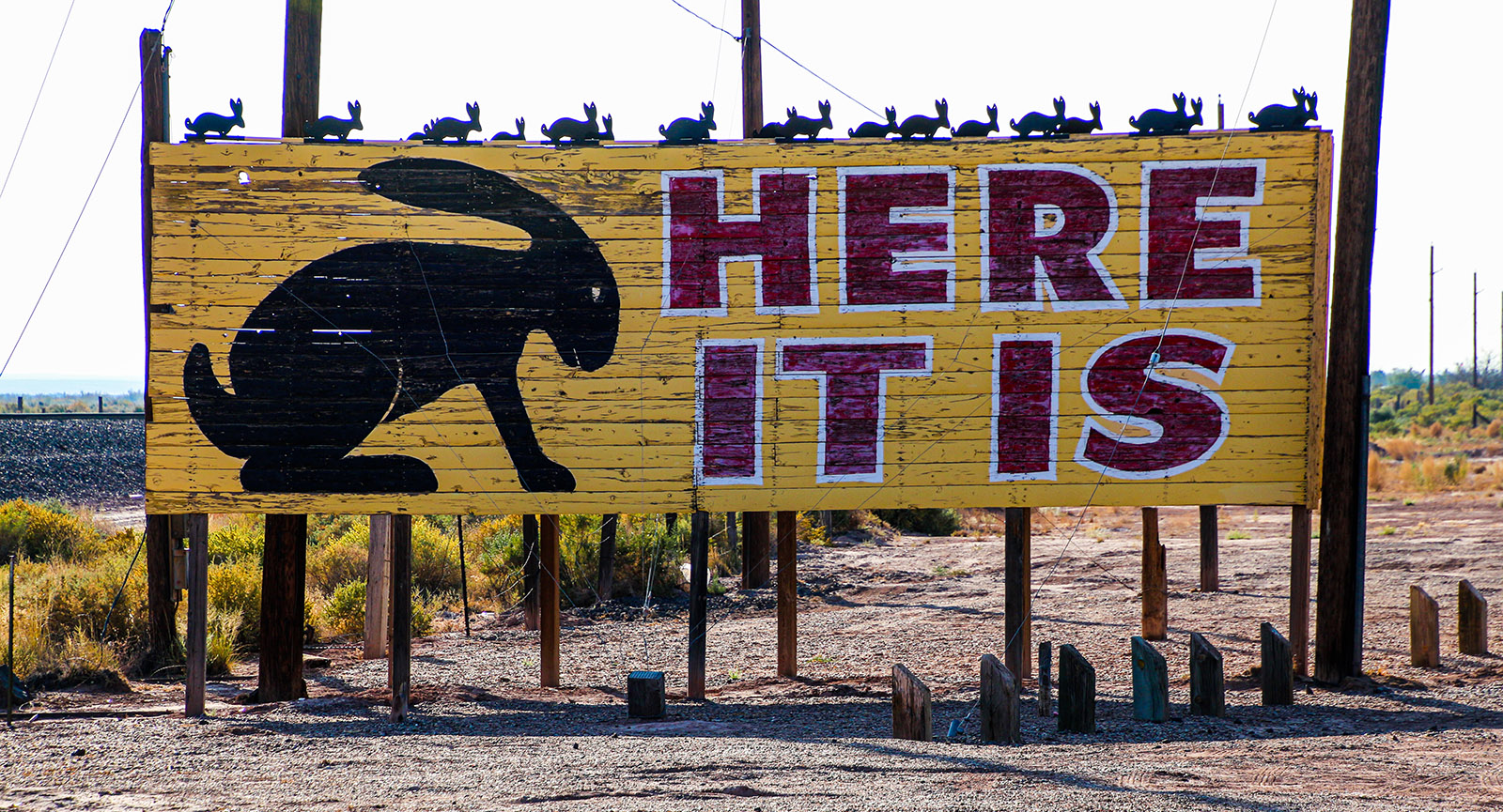
The store is still owned by the grandchildren of the original man that created it in 1949. According to the owner, the building was previously used to raise rattlesnakes.
Winslow
Winslow owes its prosperity to the railroad. After being founded in 1882, the railroad still operates a major facility here today. They also built one of the more famous Harvey Houses here in 1930, named La Posada, which is now a popular hotel that was lovingly restored and is privately owned.
Rock ‘n Roll also helped put Winslow on the map. The popular rock band, The Eagles, wrote a song named, Take It Easy, with the famous line, “Standing on a corner in Winslow Arizona…”. The song was written by Glenn Fry and Jackson Browne, and would become one of the most recognized songs in rock ‘n roll history. Little did they know that the song would help Winslow prosper as a tourist attraction.
The small downtown section of Winslow has been nicely decorated and has become a hip spot to walk around and peruse. Numerous art galleries and eateries dot the two or three city blocks. The city has done a great job of polishing up this gem of a town to make it a place where Route 66 tourists want to stop and spend some time. Coupled with the La Posada Hotel, one can spend some time in this historic Route 66 town.
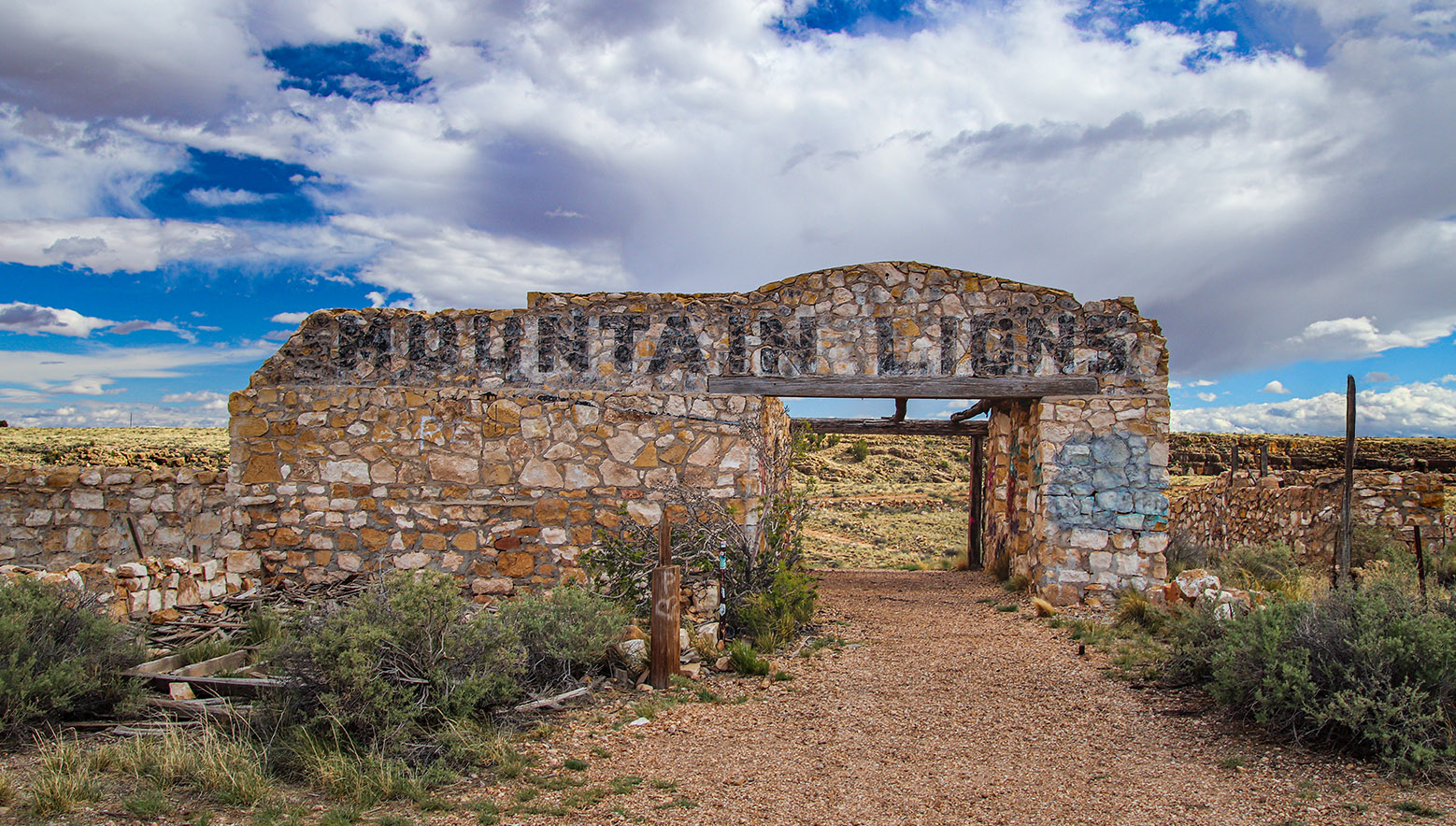
Two Guns
About 21 miles west of Winslow is an exit named Two Guns. It provides access to a roadside attraction of the same name, Two Guns. During Route 66’s heyday, Two Guns was mainly an amusement park and zoo. Ruins of cages and pits, where the animals were kept, can still be seen. They are found on the west side of the Two Guns site. One building still has the words “Mountain Lions” visible on its walls made of stone.
One attraction, located on the east end of the Two Guns site, was called the Apache Death Cave. This was supposedly the site of a battle between Apache and Navajo warriors. After the Apache attacked a Navajo camp and murdered everyone, Navajos from another camp came after the Apache attackers. Those Navajo discovered the 42 Apache hiding in this cave. The Navajo in turn burned the cave, killing all the Apache, and the name stuck as the Apache Death Cave.
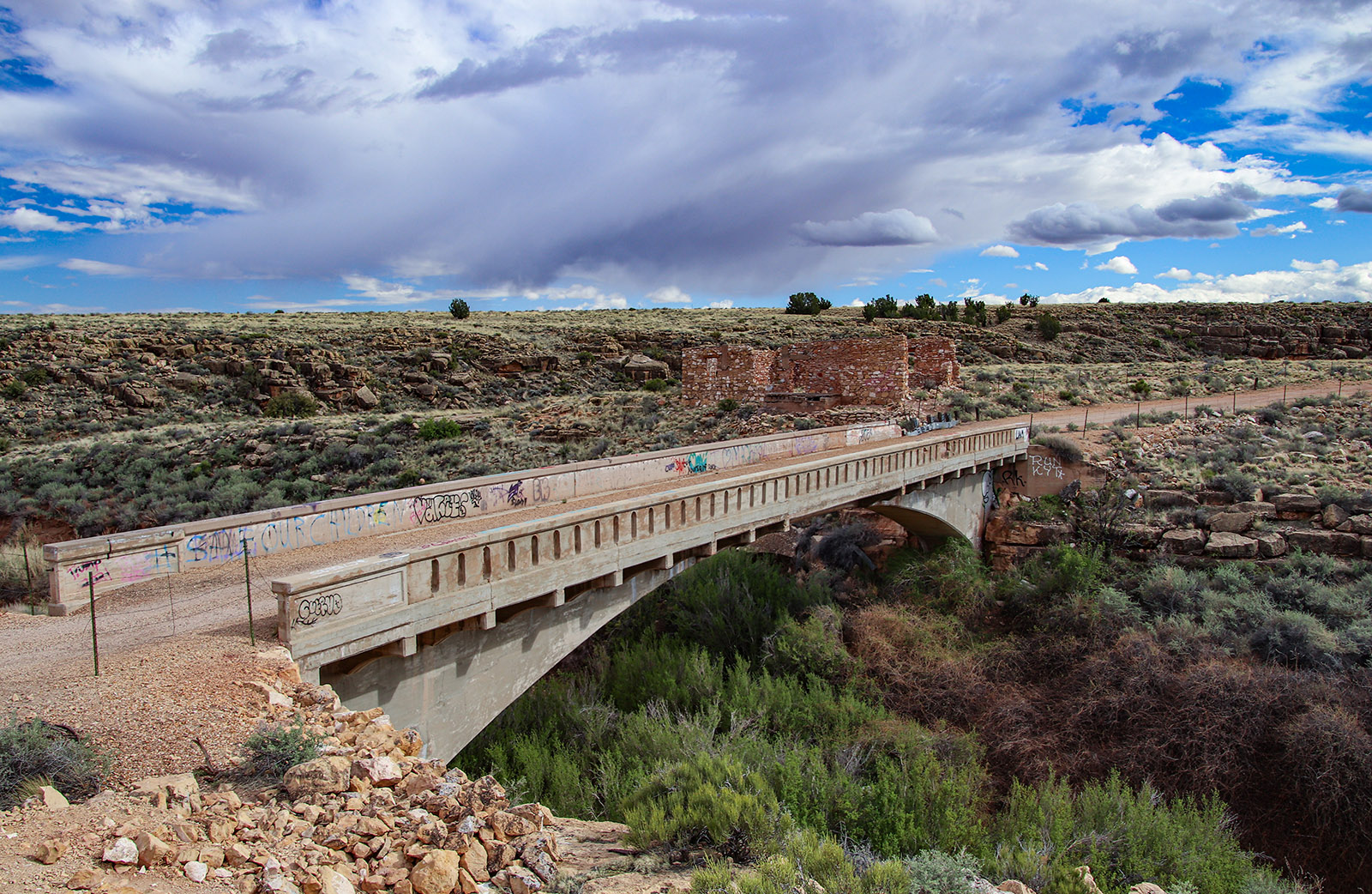
Located also on the Two Guns site is the Canyon Diablo Bridge. It opened in 1915 and was part of the National Old Trails Road. It was replaced in 1938 by a newer bridge that one side of I-40 now uses. Incidentally, at our next stop, Twin Arrows, is another similar bridge that is still in tact. Unfortunately, it is difficult to get to and is not visible from I-40 or any other road.
Twin Arrows
Twin Arrows used to be another iconic Route 66 gas station, gift shop and diner. Its unique name came from the two arrows stuck into the ground. Twin Arrows closed its doors in 1990 and has been abandoned ever since. Sadly, all that remains now are several heavily vandalized buildings. When we visited in 2020, both arrows were still standing as seen in the video. When we visited in 2024, only one was left.
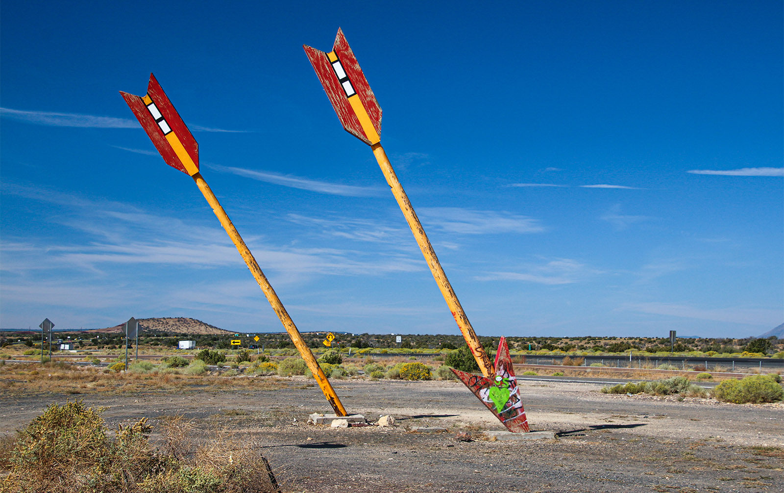
These arrows are depicted in many murals and illustrations and are iconic with Route 66 and “Indian Country”. Like other artifacts found along Route 66, they can be thought of as Americana. They are seen in the movie Cars. There is a display regarding the arrows in the Arizona 66 Museum in Kingman that we’ll visit later.
National Monuments
Between Two Guns and Flagstaff, there are several national monuments to visit that are not far off of Route 66, including the privately owned Meteor Crater, which isn’t part of any park system. All these places are worthwhile visiting. North of Flagstaff, there are two monuments, Sunset Crater and Wupatki are accessed from a loop road.
Walnut Canyon National Monument
For our tour, we’ll include a visit to Walnut Canyon National Monument as it’s the closest to Route 66, just 3 miles south of I-40. This is a great example of Native American dwellings, basically cliff dwellers, from about 1100 to 1250 AD, about the same time the Ancestral Puebloans, also known as the Anasazi, inhabited the area of Northern Arizona and Southern Utah. The dwellings at Walnut Canyon were inhabited by the Sinagua people, not the Anasazi. The Sinagua came from central Arizona, mainly the Verde Valley area.
Walnut Canyon became a national monument in 1915 after the dwellings were seriously looted by white man for decades in the late 1800s. What you’ll see here today is a fraction of what used to exist.
Visiting Walnut Creek involves walking down many steps into the canyon about a hundred feet below. The trails are on a hard surface, either rock or paved, along with stairs and handrails. The trail passes right next to a lot of cliff dwellings which are in great shape. A visit begins passing through the visitor center that has some great exhibits of the dwellings for those that don’t care to huff and puff it down, then up, the stairs. The stairway to see the dwellings is accessed from the back door of the visitor center.
Flagstaff
Before we get to Flagstaff, we don’t want to forget Winona, which is mentioned in that famous song, Get Your Kicks on Route 66, where it says, “and don’t forget Winona”. The exit to Winona is east of Walnut Canyon, so if you plan to visit the national monument and follow historic Route 66, you’ll have to do a little backtracking.
If you choose to not forget Winona, take exit 211 and travel this segment of Route 66 all the way into Flagstaff. One thing to see is a historic bridge that the old road traversed. Otherwise, there aren’t many historic sites to point out along this stretch. If you choose to stay on I-40, take exit 201, which is signed Flagstaff/Page US 89. From exit 201 to downtown, there are many old buildings and even more Americana to see on this stretch of Route 66.
A walk through downtown Flagstaff is a must. This city has prospered for so many reasons, including being a place for people in Phoenix to escape the desert heat during summer. It’s full of Route 66 memorabilia and it caters to tourists headed to Grand Canyon National Park.
One place to begin your visit is the train station, which is the visitor center for Flagstaff and located on Route 66 on the south end of downtown. There is a lot of information about Flagstaff and the surrounding area, plus docents are available to answer any questions. Their Discover Flagstaff website is full of travel ideas and has a full and up-to-date event calendar.
After seeing the visitor center, cross Route 66 and stroll through town to explore the various old buildings located around the 14 square-block downtown area. There are a few classic hotels that were open during Route 66’s heyday that are well worth admiring, or maybe staying a night or two in.
To continue the journey westbound on Route 66, simply follow the signs. In a few miles, you’ll end up on I-40. We’ll stay on the freeway until Williams. However, two nearly abandoned towns, Bellemont and Parks will be bypassed, plus an abandoned Route 66 alignment that is either eroded pavement or dirt. In the two towns, there are not many historical buildings to see.
Support Us
Help us fill up our tank with gas for our next trip by donating $5 and we’ll bring you back more quality virtual tours of our trips!
Your credit card payment is safe and easy using PayPal. Click the [Donate] button to get started:
Williams
The exit for Williams is reached about 25 miles (40 km) from Flagstaff. Take exit 165, which is signed Hwy 64, Williams, Grand Canyon. Turn left to go over I-40 and stay on this road to reach downtown Williams.
Like Flagstaff, there’s a lot going on in Williams. The town has prospered for several reasons, mainly tourism. For starters, Williams is the starting point for the Grand Canyon Railway. It starts at the old railroad station in downtown and heads to, you guessed it, the Grand Canyon. This spur of the original Santa Fe railroad was built in 1901 and was restored as a tourist railroad in 1989.
If you want to see the biggest collection of Route 66 paraphernalia of any town along the Mother Road, then you’ll want to walk around downtown Williams. You’ll get a bigger taste of the Route 66 craze here than any other place in Arizona. The streets are loaded with gift shops and eateries, as well as many nicely restored buildings that will take you back to Route 66 at its peak.
Williams was the last town where Route 66 was replaced by I-40 in 1984. Before 1984, the freeway’s traffic was ushered onto the streets that go through downtown. Imagine all the traffic along with the trucks. Luckily though, there was no Route 66 craze going on back then, nor did the Grand Canyon Railway exist yet. So, there was a lot less localized town traffic then. Now, there’s a lot more tourist-related traffic in Williams.
When you’re finished looking around Williams, head west on the main drag and re-enter I-40 westbound.
Ash Fork
Heading west from Williams, in 16 miles, exit 146 takes one into downtown Ash Fork. Ash Fork was a railroad junction town that even had a Harvey House named the Escalante. It stood across the railroad tracks on the west side of town behind the library. There is a historical marker located by the library that explains more about this Harvey House that also serviced passenger trains bound for Phoenix, as well as points east and west on Santa Fe’s mainline.
The railroad junction is now gone as the mainline was moved north of here several miles, in 1960. Only the connector line from Phoenix passes through town now. Now, only a few freight trains go by per day. Like so many towns along Route 66, after I-40 bypassed the town in the 1970s, Ash Fork was doomed.
Route 66 through Ash Fork consists of two one-way streets. Sadly, many of the buildings reflect the economic state of this once thriving town that relied on the Santa Fe railroad. The old Santa Fe water tower, sporting the Santa Fe logo, still sits on the west side of town, which is actually owned by the town’s water department.
Like in Williams, on the west side of town, jump back onto I-40 headed westbound.
Beginning of 158 Mile Stretch
About five miles from Ash Fork, take exit 139, and turn right following the signs for 66. This exit begins the longest stretch of uninterrupted, original Route 66 alignment, which is 158 miles long. From this point on, it can be driven all the way to the California border without getting onto I-40. Ironically, the Arizona/California border on the Colorado River interrupts that stretch as I-40 is the only way to cross the river.
This first stretch of the old road veers away from the freeway and beelines it to our next stop, Seligman. Driving this part of Route 66 will give you a real sense of driving a lonely stretch of the Mother Road, as not many people travel this particular segment between I-40 and Seligman.
Along this stretch of road, the first set of Burma Shave signs will be encountered. They provide some historic humor with their various words of wisdom. Between the freeway exit and Seligman two different sets of signs will be seen. There will be a few more sets between Seligman and Kingman.
Before 1950, this form of advertising was found on many highways in the USA. Burma Shave used these signs extensively until the company was sold off in 1963. The signs you see today were erected after the modern Route 66 preservation movement in the 1990s. Ironically, in the 1950s, there were Burma Shave signs in all 48 states except for Arizona and, in 2024, there are no Burma Shave signs in any of the 50 states, except for in Arizona! Thanks goes to the many Route 66 preservationists described earlier that have added new “artifacts” to the Mother Road, such as these signs, giving visitors another example of what traveling the old road was like.
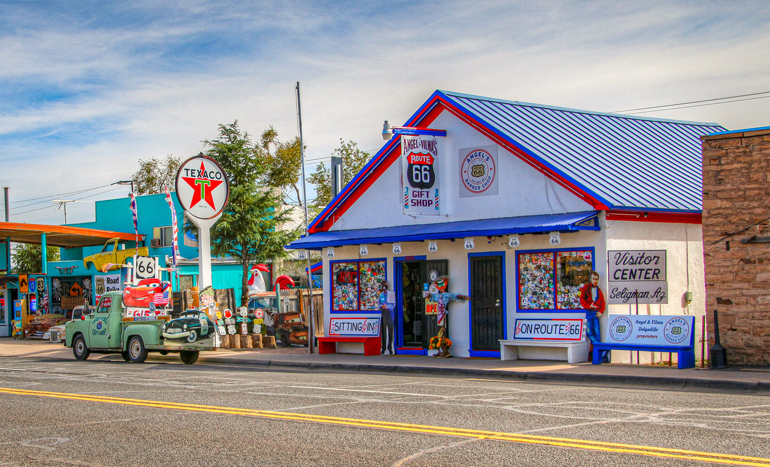
Seligman
After exiting I-40, Seligman is reached in 17 and a half miles. You’ll start seeing the town in the distance as you approach it.
Seligman is the birthplace of the historic Route 66 resurrection and preservation movement that began in the late 1980s. The first point of interest is on the left, which is Angel’s barber shop, museum and gift shop. This is where that birth actually took place around 1985.
Route 66 was fully decommissioned in 1985 after I-40 was fully completed. It didn’t take long for tourists, mainly European ones, were seen visiting old sections of the highway while admiring and photographing the old deteriorating buildings.
Barbor Angel DelGadio noticed this in Seligman and other towns and thought that maybe they should do something about it. So, in 1985, Angel and his brother Juan, plus several others, started the Historic Route 66 Association of Arizona, the first group in the nation that focused on saving Route 66. Then the international Route 66 movement began, further drawing in the Europeans, and the rest is history. Soon, other states that Route 66 formally pass through started their own historical association.
Shortly after, the association organized the Kingman Fun Run, even though it was created in Seligman. Kingman was simply better known than little Seligman. The first fun run was in 1988 and is now the oldest, continuous running Route 66 event. Today, the event pulls in a large crowd of roadies that drive their classic cars from Kingman to Seligman along the stretch that we’ll drive down next.
As you drive down Seligman, you’ll notice old hotels, businesses, gas stations and cafes all decked out with the Route 66 theme. Some show off the Cars movie characters. Others make fun of their remote location on the Mother Road. If you look around this small town, you’ll find a lot of character. The residents of Seligman were not going to see their town die like many of the others after the building of I-40. Instead, they made it quite a fun little town to visit that’s full of life.
Before leaving Seligman, make sure you have over 100 miles of fuel in your gas tank because there may be no fuel available until you reach Kingman. When leaving Seligman heading west, make sure to follow the main road and not get on a road that leads back on I-40.
More Open Stretches
Immediately after leaving Seligman, you’ll really get a feel for how remote this segment of the road is, as it passes through wide open, flat terrain that’s less than 20 miles from the Grand Canyon. You’ll also see another set of Burma Shave signs. This stretch of Route 66 between intersections with I-40 is about 83 miles (133 km) long.
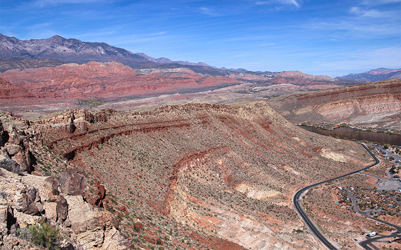
A few miles past Seligman, you’ll see the Grand Wash Cliffs on the right heading off to the north. This marks a transition between the Colorado Plateau and Mojave Desert ecosystem and geologic provinces. Route 66 entered the Colorado Plateau just west of Albuquerque, New Mexico, and, from this point, it will stay inside the Mojave Desert until it crosses the Cajon Pass and descends into the Los Angeles area.
Grand Canyon Caverns
After traveling from Seligman thru 25 miles of remoteness, we reach the turnoff to Grand Canyon Caverns. When driving this stretch of Route 66 before I-40 was built, the turnoff to Grand Canyon Caverns had the only brief passing lane for about 70 miles (112 km). By the early 1970s, US 66 was seeing a big increase in traffic and this long segment of highway was often frustrating to drive with being stuck behind slow moving trucks and RVs.
Like Two Guns, Grand Canyon Caverns was a popular roadside attraction that lost its lifeline when I-40 was moved 20 miles (32 km) to the south. Suddenly, there were no more cars traveling by whose occupants needed a break from riding this long stretch of road and needed someplace to get out of the car, walk around and see something interesting. And there are plenty of interesting things to see at Grand Canyon Caverns. As the name implies, the attraction revolves around an underground cavern. And, for the kids, there’s plenty of odd things to look at here, including many models of dinosaurs.
The caverns are not the normal caverns you may be familiar with, such as those with stalactites and stalagmites. They’re known as “dry” caverns, in fact, they’re the largest dry cavern system in the USA. They formed like other caverns in limestone, but the spring water that formed them dried up a long time ago.
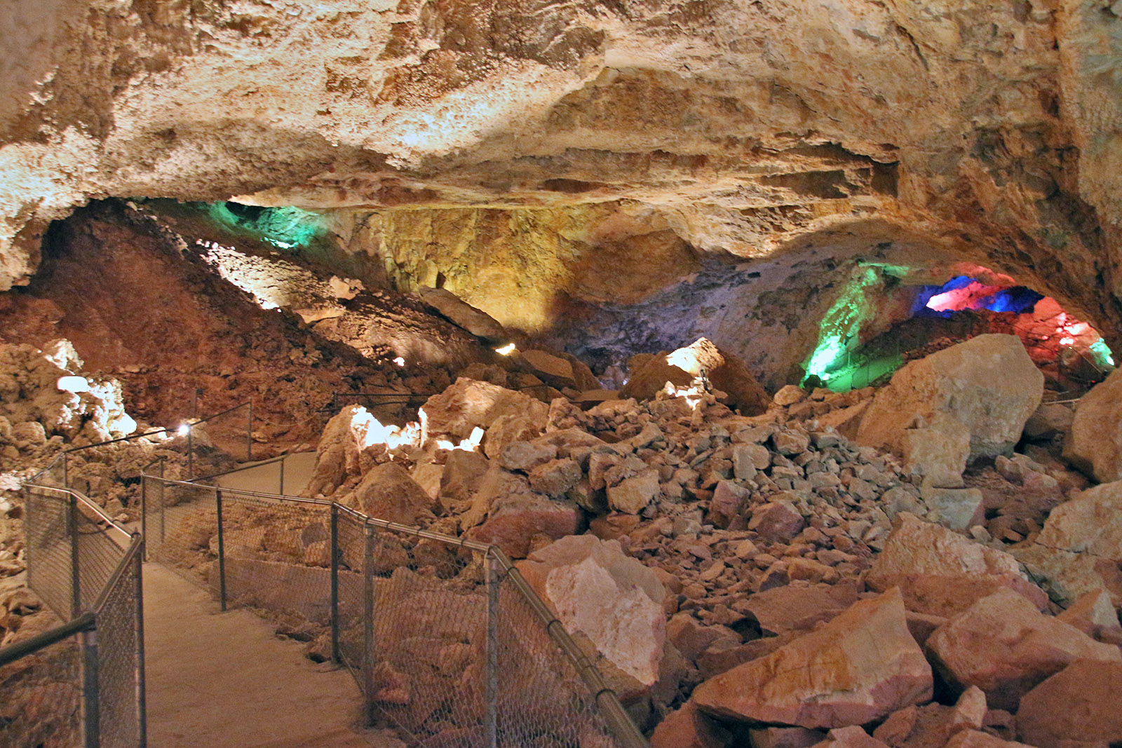
All the property of Grand Canyon Caverns is privately owned. It includes a full-service hotel, campground, restaurant, a store, a museum, and of course the caverns themselves, which are below the museum and accessed by an old and classic rickety elevator. The store and hotel are close to Route 66, where the campground, museum, and caverns are a mile from the road to the south. Along with all the artifacts of Americana laying around, Grand Canyon Caverns makes for a great basecamp to explore this remote section of Route 66.
Learn more about the geology and history of Grand Canyon Caverns.
Side Trip to Grand Canyon
Between Grand Canyon Caverns and the next town, Peach Springs, are two roads that lead north into the Grand Canyon. Both routes pass through the Hualapai Indian Reservation and require a paid permit for access, as they cross tribal lands protected by the Hualapai Nation.
One road ends at the Havasupai Trailhead where you can hike down into the Grand Canyon and to the town of Supai, which is next to beautiful Havasu, Mooney and Navajo waterfalls. The road to the trailhead is 60 miles (96 km) in length one-way, where one would park their vehicle and then hike 6 miles (9.6 km) down into the Grand Canyon to Supai, then another 2-3 miles to the waterfalls.
The other road goes down Diamond Canyon, all the way to the bottom of the Grand Canyon, where you can literally dip the front wheels of your vehicle into the Colorado River. This dirt road descends 3,400 feet (1,036 m) in just 20 miles (32 km). It’s a great way to see a section of the Grand Canyon that is seldom visited.
For both of these roads (to Havasupai Trailhead and Diamond Canyon), make sure to purchase a permit to drive on them from the tribal office in Peach Springs. The fines for not having a permit are steep.
Peach Springs
The largest town along this stretch of Route 66 is Peach Springs. It’s the headquarters for the Hualapai Reservation. Some say Peach Springs was the inspiration for Radiator Springs in the movie Cars, though several towns along the route also claim the same distinction. In truth, the film’s producers toured many locations on Route 66—including Peach Springs—to gather ideas for the charming details featured throughout the movie.
Peach Springs has a fairly new hotel and resort where road permits for the roads mentioned earlier can be purchased. The town also sports its own collection of old buildings from Route 66’s heyday.
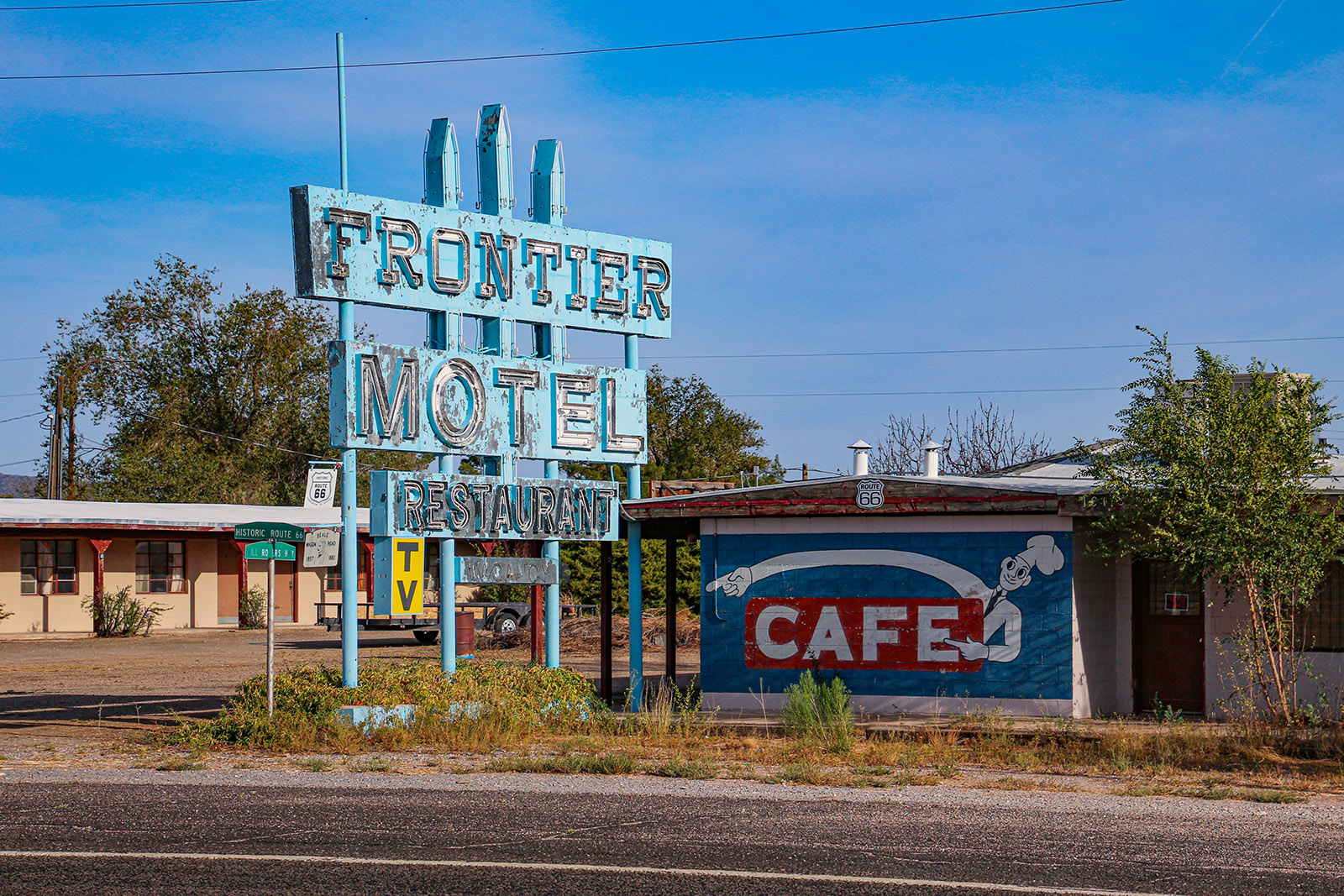
Truxton
About 8 miles past Peach Springs, the road crosses a long flat area and then reaches the town of Truxton. Here, more old buildings from the Route 66 era can be found. One of them is the Frontier Motel and Café. As depicted in one of Bob Waldmire’s postcards, the Frontier used to be a hub of activity and served home-cooked meals, even long after I-40 opened. As of 2024, it doesn’t seem to be open.
About 6 miles after Truxton, Route 66 descends into Truxton Canyon and hugs the railroad tracks. The scenery here changes dramatically as compared to the wide-open space starting in Seligman. A unique zoo that is opened to the public, named Keepers of the Wild Nature Park, will be passed.
Hackberry & Antares
About 5 miles after Truxton Canyon, the locality of Hackberry is reached. For Route 66 travelers, there are several restored gas stations and businesses scattered around here, but the must-stop place here is the Hackberry General Store. It’s the only building that’s loaded full of Route 66 meromelia and genuine Americana – you can’t miss it!

This old store turned tourist attraction has had many owners, one of them being Bob Wildmire. His influence can be seen all over the store, especially on the walls. Bob painted a few of his famous detailed maps on a few of its walls. Many of his postcards can be found for sale here.
This old and nicely decorated store is a real treat. Walking around the grounds, you’ll find a lot of old cars, buildings, signs of all sorts from various eras and other artifacts. If you’re a photographer and this type of stuff interests you, you might find yourself spending a lot of time here.
Although there are plenty of antiques laying around the property to enjoy, a walk inside the store will reveal even more antiques – and these are for sale! It might even take one longer to look through the wide collection of Americana for sale inside the store.
Five and half miles from Hackberry General Store is the small town of Antares. This is a quick stop if you like looking at some interesting and unique art pieces. This centerpiece is named Giganticus Headicus. It resembles a large head, similar to those found on Easter Island in the South Pacific. Scattered around the property are more unique art pieces made by the same artist.

Kingman
Kingman is the second biggest town along Route 66 in Arizona behind Flagstaff. The town unofficially begins when Route 66 and the railroad tracks pass beneath Interstate 40. After this point, be on the lookout for painted scenes depicting memories from the past.
The main road follows the original alignment all the way through town, where you’ll see more old buildings, many of them decked out with paintings and other decorations. Just after descending down a hill, make sure to bear right onto a one-way street to see Kingman’s nicely restored downtown area.
In the old downtown district, you’ll find many more beautifully restored and preserved buildings that were rejuvenated in the 2010s. Today, Kingman has become a popular weekend spot for people coming from California, Phoenix, and Las Vegas.
In the downtown area, which is Beale Street and one block north of Route 66, you’ll find many fun stores and eateries. Most of them are located in those restored buildings. And don’t forget to look for the paintings that decorate the sides of the buildings.
Arizona’s Route 66 Museum
Kingman is also the home of Arizona’s Route 66 museum. If you’d like to learn and see more about historic Route 66, spending time at this museum to browse through all of its exhibits and displays is a must. The museum, also known as the Powerhouse Visitor Center, is located on the southwest side of the downtown area.
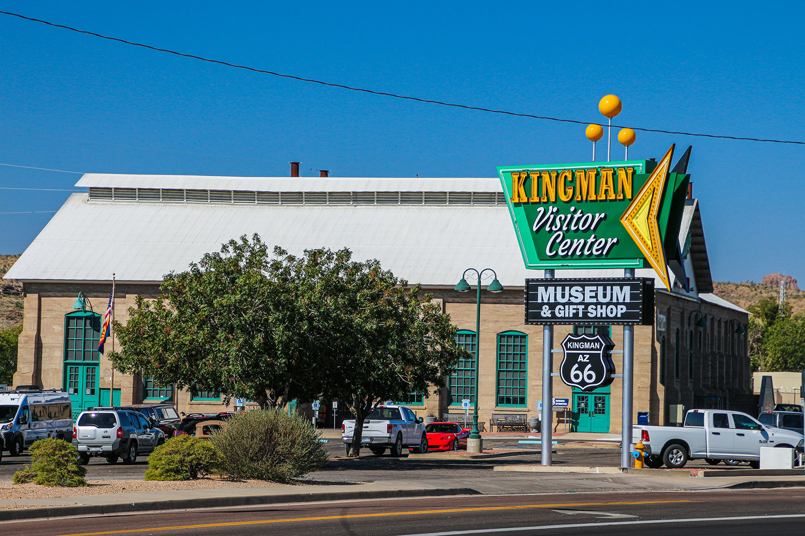
Consider spending an hour or two inside the museum. It has some of the most thorough set of exhibits and information about the history of Route 66 compared to other Route 66-oriented museums we’ve visited. When we visited, admission to the museum include admission to the neighboring Mohave Museum that focuses on the desert area around Kingman (Mohave County, Arizona). It too has a lot of fascinating information.
South of Kingman
When you’re done with the museums and ready to continue the tour, look for Route 66 as it heads south (away from the main street through Kingman) and passes through a desert canyon and several road cuts as it follows the railroad tracks. The tracks cross several bridges that are decorated with the classic old Santa Fe logo.
Continue following this section of the old alignment until it parallels and then crosses Interstate 40. Cross the freeway at exit 44, then turn left onto what’s labeled Oatman Highway on many maps. This is the original alignment of National Old Trails Road (and later Route 66) as it beelined straight to a large population center during that period—the thriving gold mining town of Oatman. More on that later.
After the popularity of Oatman died, a less precarious alignment of Route 66 was built in 1951 that followed the railroad tracks to the California border, which is the path Interstate 40 takes today. For our tour however, we’ll take that precarious route over the rugged Black Mountains.
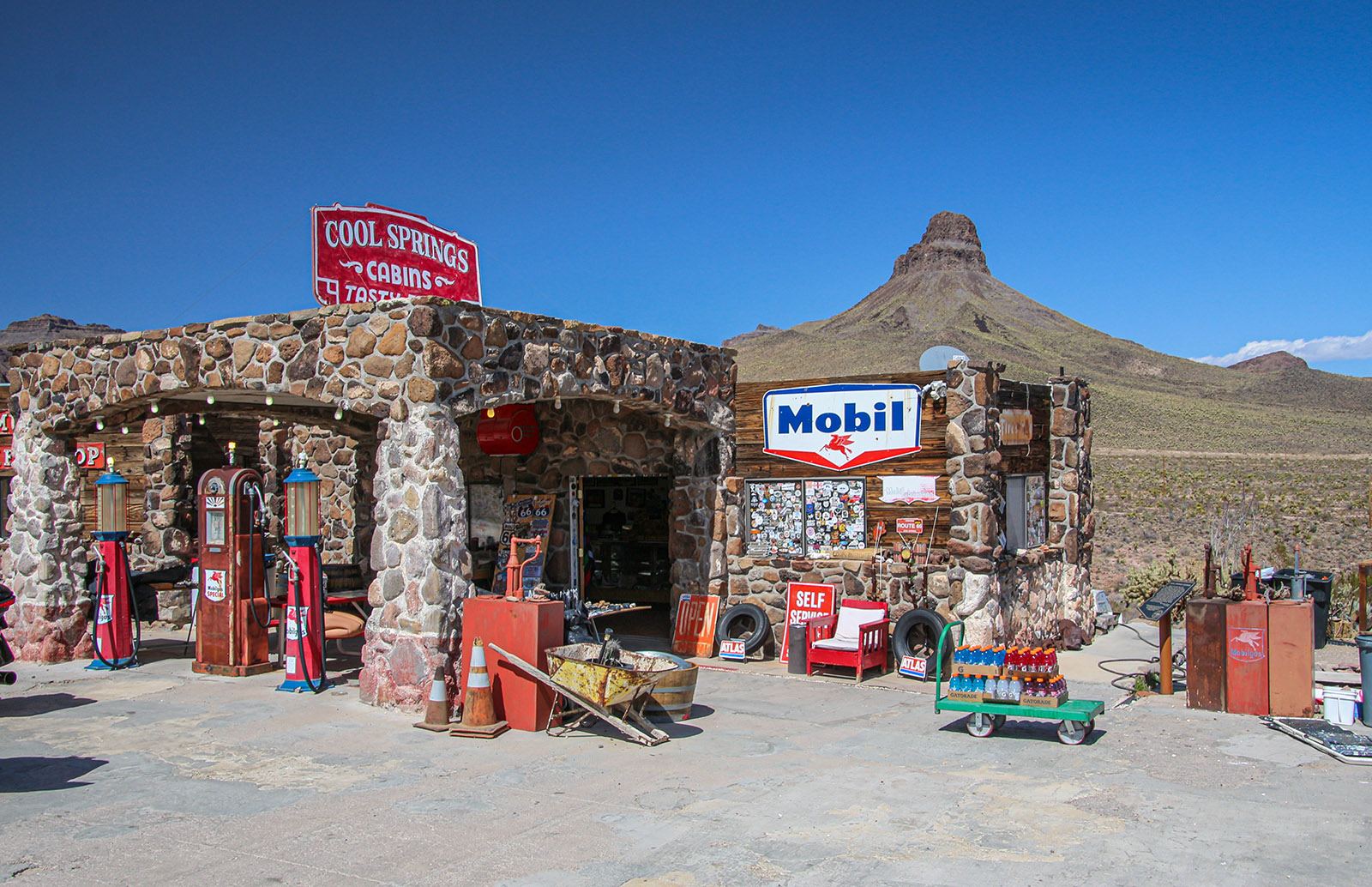
Cool Springs
After departing Interstate 40, Oatman Highway reveals sweeping views of the southern Mojave Desert, featuring native flora like cacti that thrive here and are indigenous to this arid region. From the road, travelers can admire striking geological features, including towering spires and rugged sandstone ridges that make up the Black Mountains.
As the road begins to climb the side of the Black Mountains, a point of interest is reached called Cool Springs. This was originally a gas station, café and small camp established when Route 66 was first commissioned in 1926. It survived until 1966 when it burned down.
In 2001, the land was purchased, and the camp was restored by the owner to resemble the old camp. Today, Cool Springs provides us with a great view into what this camp used to look like. This includes various antiques, just like those found at other Route 66 attractions.
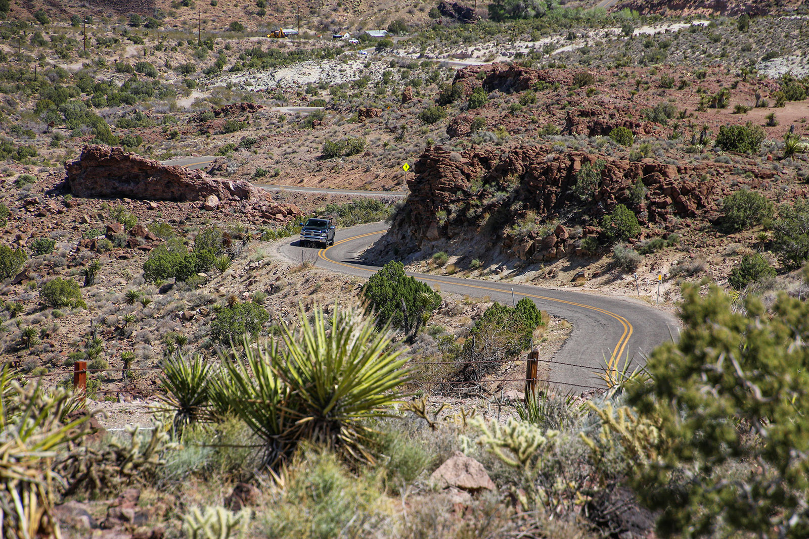
The portion of Route 66 from Cool Springs to Oatman is very scenic. It passes through the aforementioned Black Mountains causing the road’s alignment to be very twisty along with steep ascents and descents. Be prepared for mountain driving! Along with the crossing of California’s expansive Mojave Desert (see our YouTube video tour on this section from Needles to Ludlow — also see our article on DiscoverNewberrySprings.com), the section over the Black Mountains was feared by those traveling Route 66 in the 1920s to 1940s. As already mentioned, this section was bypassed with a much easier alignment following the railroad tracks in 1951.
About a mile past Cool Springs, the old establishment of Ed’s Camp is reached. It pre-dates Route 66 when it was founded by Lowell “Ed” Edgarton in 1919. Ed threw together several buildings that amazingly still stands today. The camp was a trading post to both travelers and miners in the Black Mountains. Today, the property sits on private property and its relics can be enjoyed from the road.
Also in this area are an abundant number of donkeys. This will be very evident when you arrive in Oatman. But along this portion of the road, they can be quite dangerous as they sometimes hangout in the middle of the road. Since this portion of the road has many blind corners, one can come around a bend rather fast to find a donkey in their way. The solution is to enjoy this scenic portion of the road by driving it slowly.
Crossing the Black Mountains reaches its dramatic peak at Sitgreaves Pass. Travelers heading westbound on Route 66 toward Oatman should stop at the lookout point about a quarter mile beyond the summit. The view from there offers a stunning glimpse into the expansive valley carved by the Colorado River. Just below lies the Gold Road area, home to a long-active gold mine. When we passed through in 2021, the mine was fully operational—a living reminder of the region’s rich mining heritage.
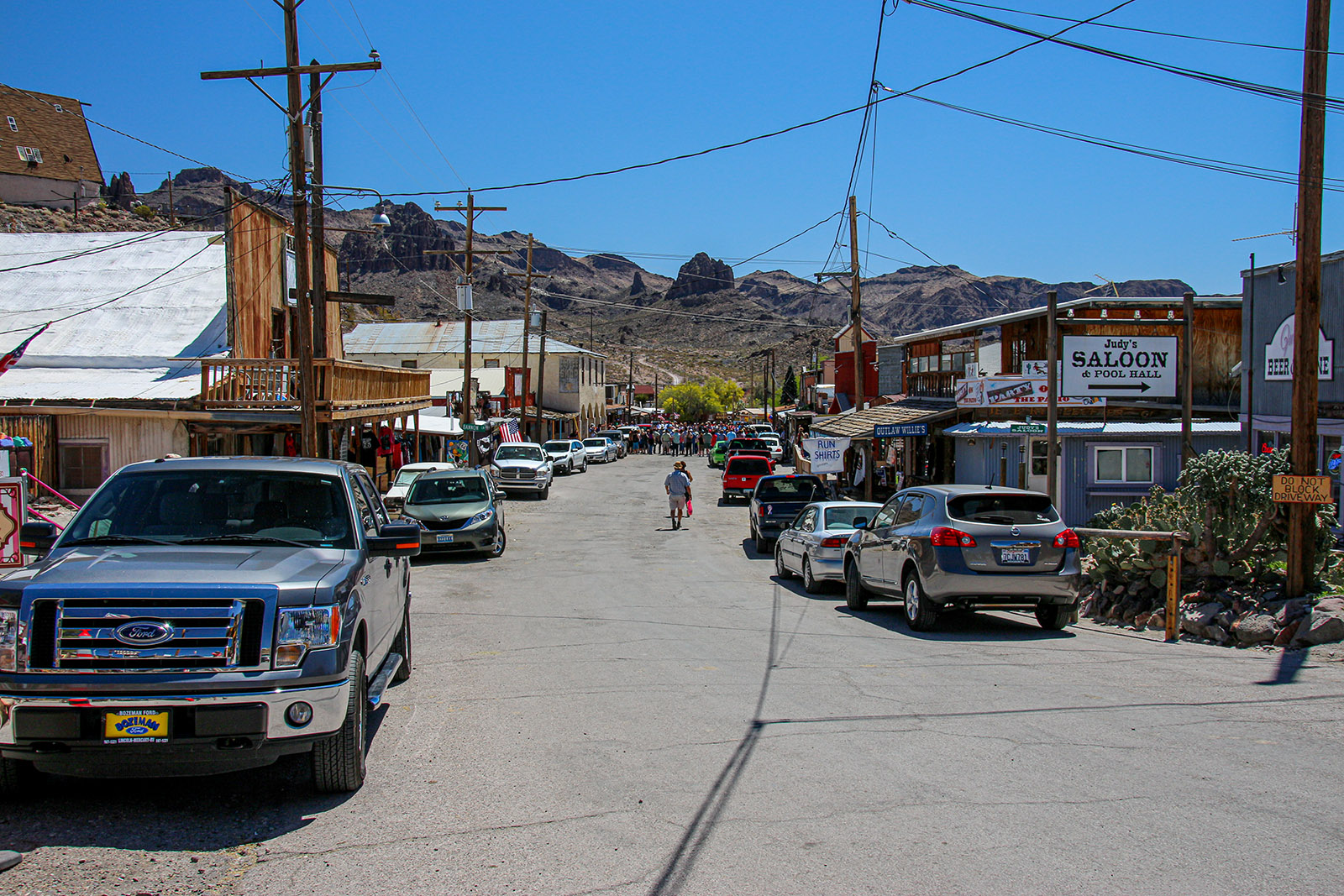
Oatman
About 4 miles from Sitgreaves Pass, the town of Oatman is reached. When you drive in, hopefully you won’t find the road closed, like we once did.
The reason for the road closure? A gunfight. Twice daily, at high noon and about 2pm, a group of gun slingers make it out to the streets and start a good ‘ol western shootout. Unfortunately, it also closes down Route 66 for about 10-15 minutes. But that’s enough time to enjoy the show.
Oatman was founded in 1906 as a gold mining camp and by 1931, over 36 million dollars in gold was recovered, making it quite a wealthy town. The mines were closed in World War 2 and the miners moved away. Then, when Route 66 was rerouted in 1951, the town began to wither away.
Today however, Oatman has became a prospering town thanks to tourism and the popularity of the casinos in nearby Laughlin. Now with the popularity of Route 66, Oatman is quite a tourist attraction and is always busy. On the weekends, expect Oatman to be very busy with it being difficult to find a place to park. The traffic also gets busy with its population of donkeys roaming around in the middle of the road along with the tourists. One must have patience when driving through Oatman!
Halfway through town, you’ll notice the Oatman Hotel on the left (east) side of the road. The famous Hollywood actor and actress Clark Gable (Gone with the Wind 1939) and Carole Lombard (To To Be or Not to Be 1942), supposedly spent their wedding night here in 1939. It was then called the Durlin Hotel. Whether the story is true or not, Clark was known to frequent the Durlin to play poker with local miners. A visit to the hotel today is worth the walk through history and nostalgia from Route 66’s heyday of the 1930s.
Along with the old buildings, the hillsides are littered with old rusty mining ruins. The combination of the weathered buildings, mines and the rugged mountains makes Oatman a photographer’s delight.
Topock
After leaving Oatman, in about a mile, bear left at a fork in the road to stay on Route 66. The road now skirts the western edge of the Black Mountains and descends into the Mojave Desert once more. This time though, it stays on the floor of the Mojave (no more big mountain crossings) for over 230 miles (368 km) until California’s Cajon Pass.
About 24 miles (38 km) from Oatman, and just after passing through the town of Golden Shores, Arizona’s portion of Route 66 comes to an end at the small community of Topock. The new resort of Topock 66 is passed just before passing underneath the Santa Fe railroad mainline. After passing under the tracks, on the left is a historic water tank that has been installed before Route 66’s existence. It’s nice that the railroad didn’t have it removed.
Just past the tank, for people that wish to travel historic Route 66 must rejoin I-40 to cross the Colorado River. But there is one more significant historic site to visit: Old Trails Bridge. This bridge was built in 1916. Travelers using National Old Trails Road before 1916 literally had to drive their vehicles on the railroad tracks, which at the time was the only bridge over the Colorado.
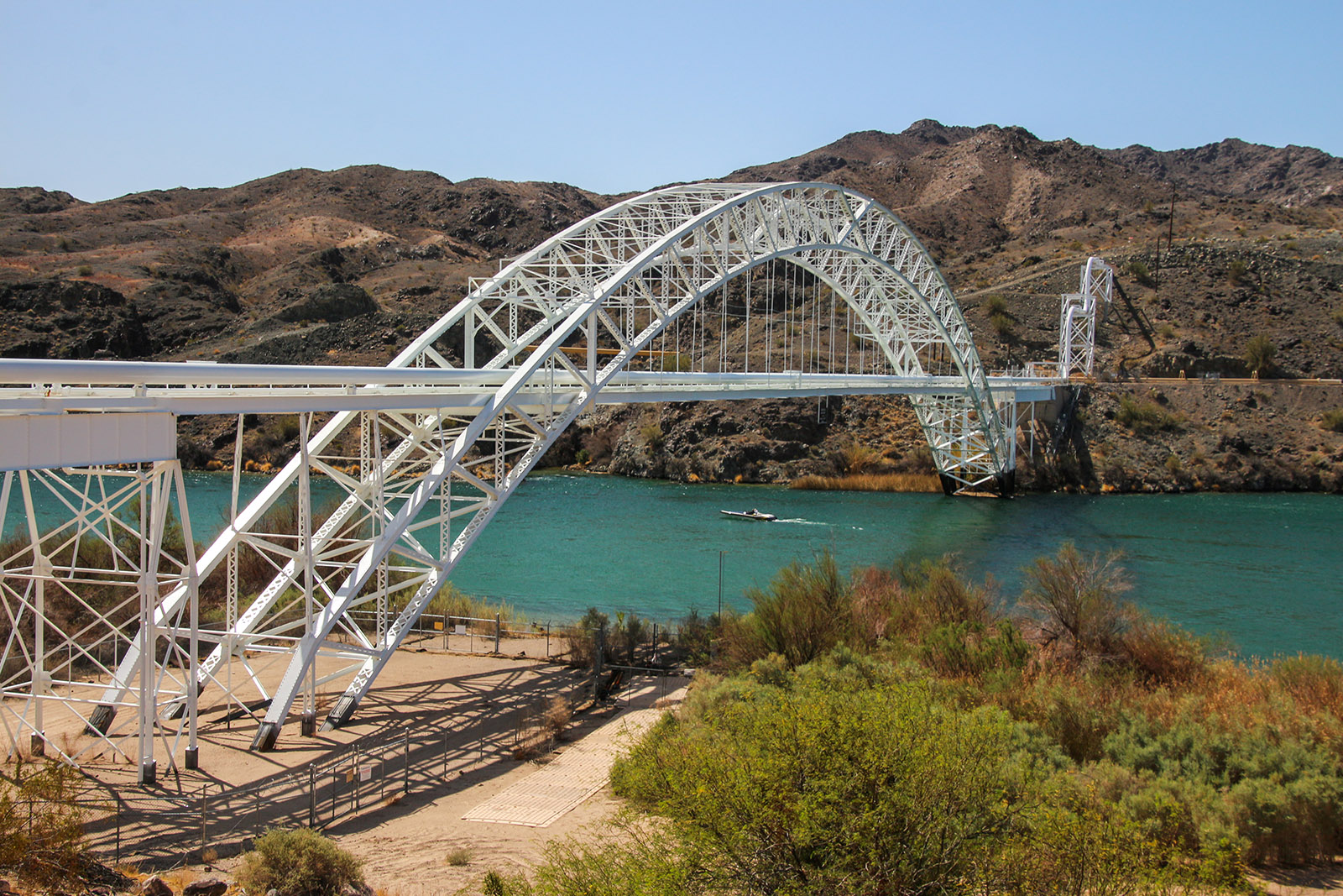
Today, the bridge serves as a PG&E natural gas line. Viewing it can be done by crossing I-40, then turn right towards the white-colored bridge. The road ends shortly after the bridge. It sits on and around private property, so enjoy views of the bridge from the road.
Another view to enjoy from this site is how the city of Needles, California, got its name. Looking 45 degrees to the left of the bridge you’ll see a small mountain of pointed pinnacles. These are the “Needles” that was named by early travelers as an obvious landmark when traveling up and down the river or along the early roads.
This marks the end of the western segment Route 66 through Arizona going westbound. From here, one can follow the old alignment of Route 66 in California by taking the next exit on I-40 named Park Moabi Road.
Comments
Read and leave comments about this post on our two accompanying videos on YouTube:
- Comments for Lupton to Flagstaff portion
- Comments for Williams to Topock portion
Support Us
Help us fill up our tank with gas for our next trip by donating $5 and we’ll bring you back more quality virtual tours of our trips!
Your credit card payment is safe and easy using PayPal. Click the [Donate] button to get started:
Subscribe
See all our comprehensive virtual tour guides at:
![]()